

Widespread power outages, strong winds slam NY area as NJ river flooding threat looms

NEW YORK CITY - A powerful storm slammed the NYC area on Tuesday, with flash flooding, strong wind gusts and the potential for additional power outages continuing to threaten New Jersey, New York and Connecticut, even as the system moves into the Atlantic Ocean.
TABLE OF CONTENT: LIVE RADAR | SCHOOL CLOSURES | POWER OUTAGE MAPS
In New Jersey, numerous rivers remain in flood stage, while water levels continue to rise on major area rivers, which will crest in the next 48 hours, the FOX Forecast Center said. Up to 4 inches of rain was reported in certain areas.
Hazardous river flooding could again force communities across the Garden State to flee their homes and businesses.
The Saddle River is reportedly in a major flood stage, according to the National Weather Service, where water rescues were reported Wednesday morning. The Passaic River also poses dangers to several communities.
Wind speed map: Where are the strongest winds?
Wind gusts higher than 60 miles per hour were reported in Queens, Long Island and Connecticut, causing widespread power outages across the area.
Featured

Power outage tracker: Thousands in the dark across NY, NJ, CT
Thousands of people throughout the entire New York City area are without power, including New York, New Jersey and Connecticut, after soaking rain and near hurricane-force winds slammed parts of the tri-state area.
Despite the system exiting into the Atlantic Ocean, strong wind gusts will persist into Wednesday evening in the Northeast, which could trigger additional power outages.
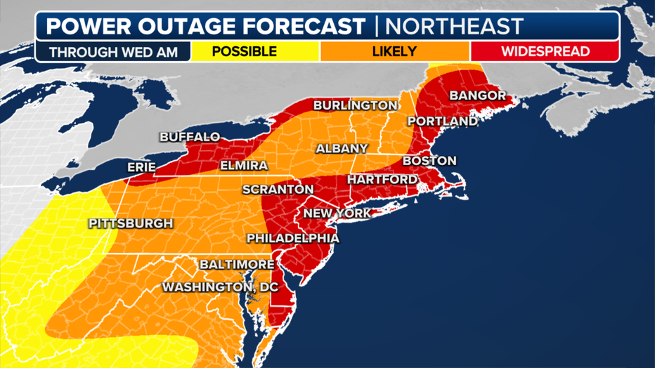
The power outage forecast for the Northeast. (FOX Weather)
Wind Advisories and High Wind Warnings have been issued for the second straight day across much of the region, as winds are forecast to gust between 45 and 60 mph.
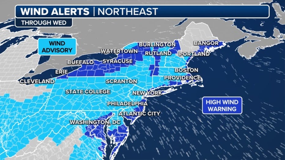
Here's a look at the current wind alerts for the Northeast. (FOX Weather)
Will rivers in New Jersey flood?
Moderate to major river flooding is likely throughout northern New Jersey, as parts of the Passaic River, Saddle River and Raritan River could crest.
Featured

NJ flooding: Rivers reach major flood stage, threats loom as water levels rise
Severe river flooding once again threatens northern New Jersey following Tuesday's storm, prompting school closings, street closures and water rescues following Tuesday's storm.
The Saddle River in Bergen County and the Raritan River in Somerset County are already in a major flood stage, according to NWS hydrographs.
The Ramapo River in Mahwah is also cause for concern. The flooding could lead to the evacuation of residents and severe damage.
Many communities in northern New Jersey are still reeling from a December storm that caused the Passaic River to crest, forcing residents to evacuate their homes, schools to close and detours on major thruways.
What coastal flood warnings, advisories, statements are in effect?
Coastal Flood Warnings and Advisories have been issued by the National Weather Service, with the worst of the coastal flooding forecast to occur in and around the Chesapeake and Delaware bays.
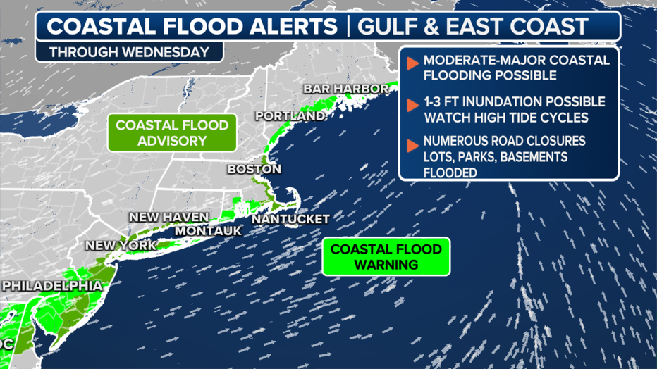
Coastal flood alerts through Wednesday. (FOX Weather)
Most of the area is under a coastal flood warning, while New York City, southwestern Connecticut, and parts of New Jersey and Westchester County face coastal flood advisories and statements.

Flood Watches are in effect across the Northeast. (FOX Weather)
Major flooding is also possible for coastal communities along the Great South Bay.
On Tuesday, New Jersey residents expected the Pompton River to rise to about 19 feet by Wednesday morning. The forecast now calls for a crest of over 20 feet on Wednesday evening.
What comes next?
As the rain ended, the flood threat did not. Instead, it will shift from a flash flood to a river flood threat.

Numerous rivers are expected to rise into flood stage, and multiple may reach moderate to perhaps major flooding.
While not quite as concerning, the setup for the river flood threat is similar to the one that led to destructive river flooding last month across the Northeast.
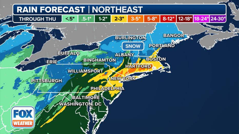
The rainfall forecast through Wednesday, Jan. 10, 2024. (FOX Weather)
Widespread minor flooding is expected in the most vulnerable locations near the waterfront and shoreline. Expect around 1 to 2 feet of inundation above ground level in low-lying, vulnerable areas.
The National Weather Service said to expect flooding not only in Manhattan, but also New Jersey, including Hudson, eastern Bergen, eastern Essex, and eastern Union counties, as well as Staten Island and Brooklyn. Significant flood impacts will likely continue into Thursday.
Potential failure of Fitchville Pond Dam in CT
On Wednesday morning, emergency management in New London County, Connecticut, reported the potential failure of the Fitchville Pond Dam along the Yantic River.
Authorities have warned of life-threatening flash flooding in areas downstream from the dam, including the town of Fitchville. The National Weather Service had issued a Flash Flood Warning.
Emergency managers also issued a precautionary evacuation of a portion of the nearby town of Bozrah.
Another NYC storm?
As one storm system exits, another event is on its heels later this week, likely producing another round of rain in parts of the tri-state area.
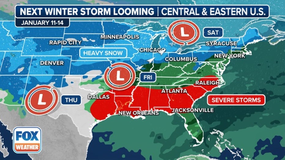
The next cross-country storm will sweep across the U.S. later this week and into the weekend. (FOX Weather)
But similar to the past two storm systems, major cities in the Northeast, including New York City, will miss out on seeing accumulating snow, with temperatures simply too warm to support frozen precipitation along the coast.
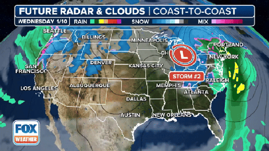
A look at the next major storm system that will move across the U.S. later this week and into the weekend. (FOX Weather)
Forecast models show some communities in the Great Lakes could pick up snowfall accumulations in the double digits with wind gusts of more than 30 mph.
The areas that will see the heaviest snow likely won’t be set in stone until around Thursday morning, when more accurate computer model runs will be able to determine where the storm system’s center will travel and how much cold air will be available.
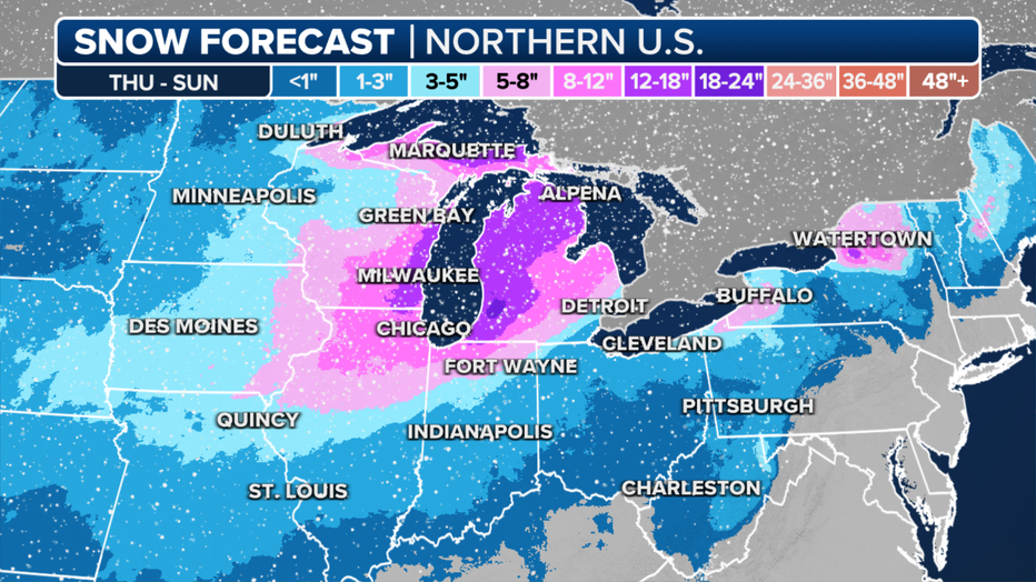
Forecast snow totals through Sunday, Jan. 14, 2024. (FOX Weather)
FOX Weather contributed to this report.