NJ flooding: Saddle River crests, more flood threats loom as water levels rise
LODI, N.J. - Severe flooding once again threatens inland and coastal New Jersey, prompting school delays, road closures and water rescues following Tuesday's storm. This comes just weeks after a December storm inundated the communities with floodwaters.
Click here to check school closings and delays. Click here to jump to rainfall totals.
At least 4 inches of rain reportedly fell in parts of Bergen and Passaic counties, landing on ground saturated by this weekend's storm. And yet another storm Friday evening will exacerbate flooding.
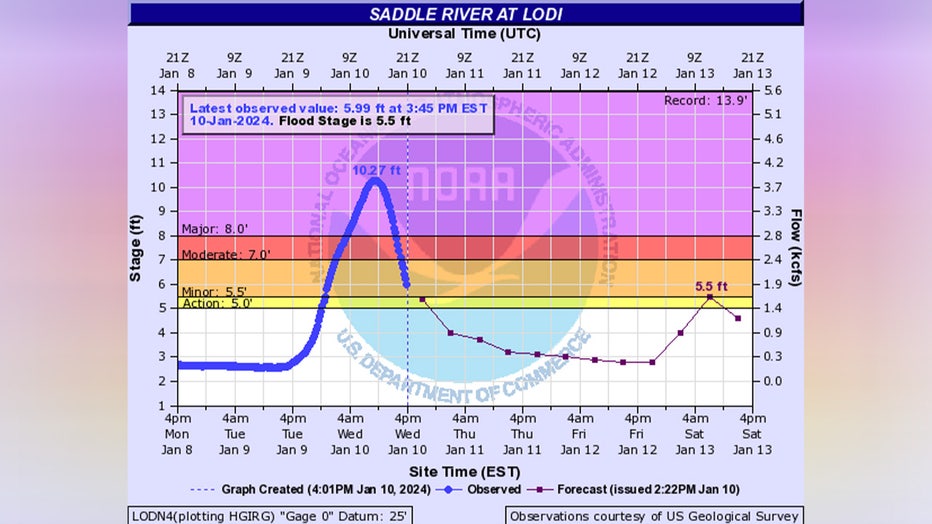
In Lodi, the Saddle River crested around 9 a.m. EST Wednesday morning, more than 2 feet above major flood stage. The river level peaked at 10.27 feet, according to the National Weather Service. The Saddle River enters minor flood stage at 5.5 feet and major flood stage at 8 feet.
Flood warnings remain in effect Wednesday morning in parts of Bergen, Essex, Passaic and Union counties.
Ahead of the storm, New Jersey Governor Phil Murphy declared a state of emergency for all 21 counties in the state. Murphy said 56,000 homes were without power and several hundred accidents and highway assists were reported, but no storm deaths.
Numerous rivers remain in flood stage, while water levels continue to rise on major area rivers, which will crest in the next 48 hours.
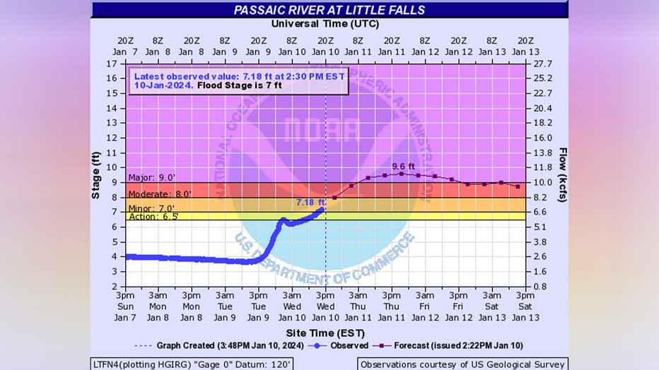
In Paterson, the Passaic River gauge is forecast to reach major flood stage, and a Flood Warning is in effect for the area until Thursday. In December, the river crested at 22 feet, which makes the area particularly vulnerable to the rain this time around.
Morris County residents expected the Pompton River to rise to about 19 feet. The forecast now calls for a crest of over 20 feet on Wednesday evening.
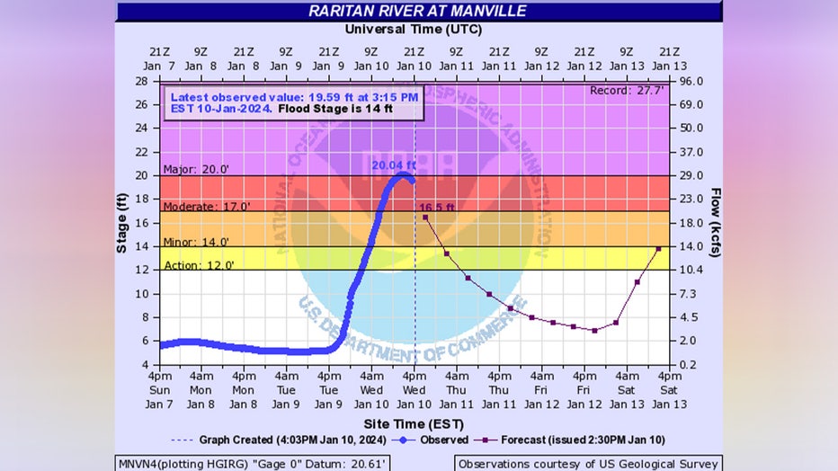
The Raritan River in Somerset County also reached a major flood stage.

A view of flooded area after winter storm in New Jersey on January 10, 2024. (Photo by Lokman Vural Elibol/Anadolu via Getty Images)
Commuters in Hoboken were greeted Wednesday morning with a flooded railway terminal, though train service remained "uninterrupted," NJ Transit officials said.
In coastal and bayside communities on the New Jersey shoreline, the high-tide cycle sent Atlantic waters onto the land. Coastal flood warnings remain in effect in Middlesex, Monmouth and Ocean counties.
Saddle River in Lodi crests

(National Weather Service)
Basement and lower-level apartment homes in Lodi were flooded when the river crested, sending water into the streets near the river, including Main Street. On Wednesday, water continued to lap at buildings, and the river raged nearby.
Avenue E to Central Avenue on Main Street remains closed due to flooding.
Lodi Fire Department crews evacuated families with young children in those homes using high-water vehicles. Fire crews are going street by street to check on residents in homes in the flooding area who may need rescuing.
Despite the flooding, people were still trying to make it to work in the wet conditions. Many drivers were diverted due to flood-related road closures.
"You need a rowboat No. 1 to come in here. It's been bad. The water rises in the rivers, and there's nothing you can do," said Phil Pino, of Pinto Garbage Co. "Main Street is bad, very bad. Maybe half a mile of water."
FOX 5 NY's Robert Moses spoke with a resident who watched helplessly as the water encroached on his home. Phil Coniglio said he's done everything to prepare for the storm after severe flooding impacted his home a few weeks ago.
"Right now, it's kind of frightening because you, you sit there, and I know what number puts it…in my house. And that number is 9.41. Right now it's at nine. So I've only got four-tenths of a foot. I've got like four or five inches. And that water just start coming to my house," Coniglio said.
Schools in Lodi are closed on Wednesday.

A view of a flooded street in a residential area after Saddle River crested and spilled into the streets of Lodi, New Jersey, causing flooding in some homes and spurring people to evacuate in some cases on January 10, 2024. (Photo by Lokman Vural Eli
The basement flooded at the Boys and Girls Club, Washington Elementary School and multiple businesses in Lodi. Flooding was also reported in houses along the baseball field and a senior housing complex.
Raritan River

(National Weather Service)
Dramatic video showed elevated water levels in the Raritan River at Manville, Somerset County, on Wednesday. Another video shows Raritan waters overflowing onto a bridge in Somerville.
"The river is still rising," @GerryGorbach wrote in an X post.
Authorities in Somerset County indicated that localized flooding was expected to persist through Wednesday afternoon.
Passaic River flood threats

(National Weather Service)
Pine Brook is bracing for major flooding impacts as the Passaic River is forecast to crest at 21.4 feet on Thursday. As of Wednesday morning, the river was over 19 feet, just above minor flood stage. The river reaches major flood stage at 21 feet.
Christopher Hope Center is open to shelter fleeing residents in Paterson.
Pompton River hit major flood stage
Pompton Plains has picked up 3-5 inches of rain over the past 24 hours. The Pompton River hit major flood stage at 19 feet and is forecast to peak at 20.6 feet by late Wednesday.
Pequannock Mayor Ryan Herd said that beginning Sunday, first responders went door to door to warn residents of the potential flooding. The mayor said he's concerned families will be displaced by flooding yet again.
"This is actually about the third time in about four weeks that we've gotten flooding in Pequannock," Herd said.
How much did it rain in NJ? Local rainfall totals
Bergen County
- Franklin Lakes 4.48 in
- Oakland 3.34 in
- Glen Rock 3.31 in
- Mahwah 3.14 in
- New Milford 2.90 in
- Park Ridge 1.0 in
- Bergenfield 2.80 in
- Paramus 2.75 in
- Ramsey 2.73 in
- Teterboro Airport 2.67 in
- Westwood 2.66 in
- Tenafly 2.63 in
- Fair Lawn 2.58 in
- Hasbrouck Heights 0.9 in
- Lodi 2.48 in
- North Arlington 2.48 in
- Montvale 1.8 in
- Tenafly 2.47 in
- Hasbrouck Heights 2.45 in
- Emerson 2.30 in
- Hillsdale 2.23 in
- River Edge 2.21 in
- River Vale 2.15 in
- Park Ridge 2.14 in
- Hackensack 1.96 in
- Lyndhurst 1.93 in
- Bogota 1.89 in
- Leonia 1.61 in
Essex County
- Essex Fells 3.87 in
- Verona 3.71 in
- Cedar Grove 3.36 in
- Caldwell 3.23 in
- Livingston Twp 3.18 in
- Montclair 3.17 in
- West Caldwell Twp 3.09 in
- Millburn 2.92 in
- West Caldwell 2.90 in
- Montclair 2.45 in
- Fairfield 2.44 in
- Maplewood 2.40 in
- Orange Reservoir 2.32 in
- Millburn 2.18 in
- Newark 2.11 in
- Maplewood 1.99 in
- Kearny 1.75 in
Hudson County
- Harrison 2.60 in
- Jersey City 2.60 in
- Hoboken 2.35 in
- Kearny 2.21 in
- Secaucus 2.16 in
- Weehawken 1.73 in
Passaic County
- Oak Ridge Reservoir 4.40 in
- West Milford 4.39 in
- West Milford 4.28 in
- Charlottesburg Reservoir 4.12 in
- 2.1 E Ringwood 3.96 in
- 1.5 SW Ringwood 3.88 in
- Wayne 3.86 in
- Hawthorne 3.76 in
- Little Falls 3.71 in
- Wayne 3.70 in
- West Milford 3.66 in
- West Paterson 3.40 in
- Wayne 3.32 in
- Ringwood 3.16 in
- Wayne 2.76 in
- Hawthorne 2.50 in
- Pompton Lakes 2.49 in
Union County
- Bayside 3.61 in
- Mountainside 3.28 in
- Westfield 2.76 in
- Summit 2.61 in
- Westfield 2.46 in
- New Providence 2.40 in
- Cranford 2.38 in
- Linden 2.34 in
- Union 2.31 in
- Clark 2.26 in
- Newark Airport 2.22 in
FOX Weather contributed to this report.


