Fire Weather Watch: NY-NJ wildfire continues to burn acres | Weekend forecast, updates, maps

Exhausted crews worn out battling NJ, NY wildfires
The NYC Tri-State is the driest it’s been in nearly 120 years, creating perfect conditions for wildfires to spark and grow. FOX 5 NY’s Richard Giacovas reports from Greenwood Lake, New York, talking to exhausted crews and sharing updates from the ground.
NEW YORK - The Jennings Creek Fire, a large wildfire burning along the New York-New Jersey border, has scorched nearly 7,000 acres as of Friday.
Containment efforts have made significant progress, with 75% containment reported in New Jersey and 69% in New York, according to state officials.
JUMP TO: NYC Impacts | Wildfire maps | Burn ban | Drought update

Brush fire concerns: Could things get worse?
Fifteen counties in New York are under a drought watch thanks to a continuous lack of rain. FOX 5 NY's Hayley Fixler has the details.
Crews from both states, supported by specialized firefighters from Montana, are focused on strengthening containment lines and tackling hotspots.
The fire has caused considerable damage in Passaic County, NJ, and Orange County, NY, particularly around Greenwood Lake, where local schools remain closed.
The New Jersey Forest Fire Service has warned that smoke could linger until significant rainfall occurs, though dry conditions and low humidity are expected to persist through next week, with levels dropping to 30-40%.

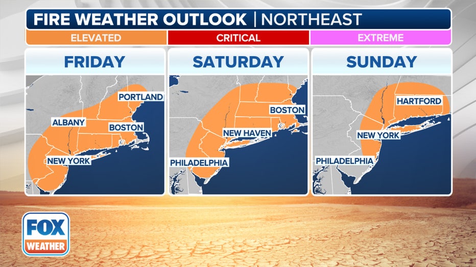
Fire Weather outlook for this weekend. (FOX Weather)
Smoke in NYC
Winds have carried smoke into New York City and nearby New Jersey counties, including Essex, Union, and Monmouth.
Residents in Edison, NJ—about 60 miles from the fire—have reported strong smoke odors.
The EPA has issued a "moderate" air quality advisory, urging sensitive groups, such as children, pregnant individuals, and those with respiratory conditions, to limit outdoor activities.
Officials recommend using indoor air purifiers and staying informed through air quality alerts. Smoke is expected to drift back into Manhattan and surrounding areas this weekend, according to the FOX Forecast Center.
Weekend Fire Forecast

A look at the fire weather alerts issued in the Northeast through Tuesday. (FOX Weather)
Elevated fire weather concerns remain on Friday for Northeast New Jersey, the Lower Hudson Valley, New York City and Long Island.
NY State Burn Ban
New York Governor Kathy Hochul has extended New York's statewide burn ban through November in response to the ongoing wildfire threat.
This fall has already seen five Fire Weather Warnings in the state, a rare occurrence outside New York's typical fire season of March to May.
Dry vegetation, fallen leaves, and breezy conditions will continue to heighten the risk of flare-ups along the I-95 corridor. Emergency officials urge residents to stay vigilant and follow local fire safety guidelines.
For real-time updates on containment efforts, smoke advisories, and air quality, visit New Jersey’s wildfire tracking map or New York’s Department of Environmental Conservation website.
NJ Drought Warning

Tri-state wildfires rage amid drought
As wildfires continue to spread across the Tri-State area, firefighters are working tirelessly to contain the flames in Ringwood state Forest, where intense drought and strong winds are fueling the blaze. FOX 5's Richard Giacovas has the story.
State geologist Steven Domber told the Associated Press that water levels are declining across New Jersey.
"Please take this seriously," NJ Gov. Phil Murphy said. "We have a very dry winter ahead of us."
But it stopped short of mandatory water usage restrictions, which would be included in the event of a drought emergency, the highest alert the government can impose.
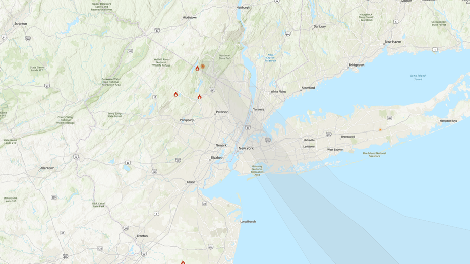
Wildfire maps

24-hour Tri-State fire map. (Captured Saturday morning)
AirNow has an interactive Fire and Smoke Map for updates on blazes in your area. The National Interagency Fire Center has also partnered with NASA to provide real-time interactive fire maps.
Air quality map
This map from AirNow.gov shows the current air quality in the New York City area. Click HERE if you're having trouble viewing the embedded map.

