Winter storm blasts NY, Northeast with snow, beneficial rainfall l Timeline

Over an inch of rain in NYC as storm hits region
New York City has received just over an inch of rain, not nearly enough to end the drought but definitely helpful, a winter storm hits our region, dropping potentially as much as a foot of snow in areas of upstate New York and parts of the southern tier.
NEW YORK - A potent winter storm system over the Northeast is bringing snow, beneficial rain and strong winds as millions of people prepare to travel ahead of the busy Thanksgiving holiday.
JUMP TO: NEW YORK SNOW l HOURLY FORECAST l NYC WINTER PREDICTION l WEATHER TODAY
Nearly an inch of rain fell on the city Thursday, with more showers on the way, but the storm hitting our region is expected to drop up to 4-8 inches of snow in areas like western Sullivan County and The Poconos.
Snow fell as far south as Westchester County, with heavy, wet snow covering the roads overnight and making driving difficult.

Snow-covered roads in Westchester County.
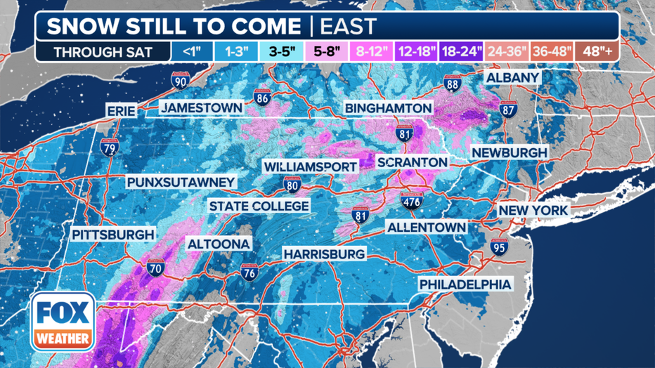
Northeastern Pennsylvania and the Catskills of New York will see the heaviest snow, with up to a foot piling up in the higher elevations there.
While travel will peak next week, some people have decided to hit the roads and pack airports early, hoping to beat the holiday rush. AAA said a potentially record-breaking 80 million people are expected to travel more than 50 miles from home this year.
24/7 NYC Live Cam | Times Square, skyline, streets, more
The Transportation Security Administration said it too was preparing for what could be the busiest Thanksgiving travel period on record.
Weather forecast snow storm
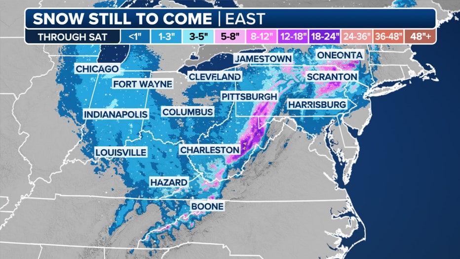
The FOX Forecast Center said that impactful snow is also expected through the Allegheny Mountains of West Virginia, Maryland and Pennsylvania through the end of the week due to a longer-duration upslope snow setup.
"Now, what sticks out, of course, are those purples," FOX Weather Meteorologist Craig Herrera said in reference to the forecast snow totals map. "Those are going to be portions of the West Virginia mountains up into portions of Pennsylvania. Of course, we’ll see that over the Poconos."

This graphic shows the forecast snow totals in the mid-Atlantic and Northeast. (FOX Weather)
Most of New England and parts of the Northeast will likely only see beneficial rain from this event due to warm air surging in from the Atlantic Ocean, but the higher elevations and locations directly under the cold upper-level low-pressure system may see heavy snow.
Love our weather updates? Get real-time alerts on our FOX LOCAL app!
Will it snow this week?
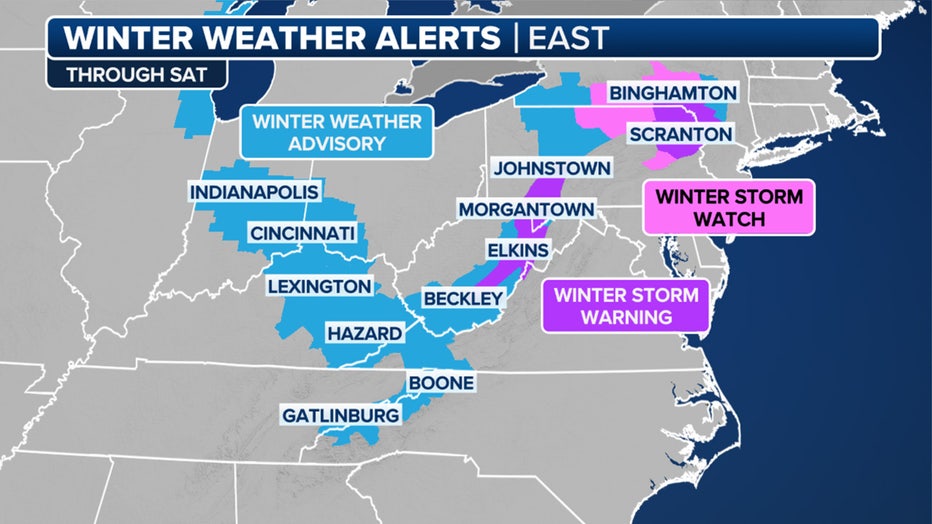
Northeast Pennsylvania and the Catskills will see the heaviest snow, with up to a foot falling in the higher elevations there. Since Wednesday, Winter Storm Watches have expanded to include more areas of New York state.

This graphic shows active winter weather alerts in the mid-Atlantic and Northeast. (FOX Weather)
The National Weather Service office in Binghamton warned of a potential "high-impact winter storm" in its forecast discussion on Wednesday. On Thursday morning, forecasters warned about the potential for heavy snow.
The NWS said there are strong signals that banding could move into Sullivan County in New York and Pike County in Pennsylvania and could track along Interstate 86 through the overnight hours toward Broome County in New York.
"Snowfall rates under the band have the potential to be 1-3+ inches per hour for several hours," the NWS said.
How much snow are we getting Thursday?
The NWS said there are strong signals that banding could move into Sullivan County that could track along Interstate 86 through the overnight hours toward Broome County.
"Snowfall rates under the band have the potential to be 1-3+ inches per hour for several hours," the NWS said.

This graphic shows the forecast snow totals in the mid-Atlantic and Northeast. (FOX Weather)
Computer forecast models are also showing certain areas in Pennsylvania and New York could see a foot or more of snow.
Pennsylvania snow forecast
Meanwhile, the FOX Forecast Center said impactful snow is also expected through the Allegheny Mountains through the end of the week due to a longer-duration favorable upslope snow setup.
Winter Storm Watches also expanded to include more areas of Pennsylvania, while Winter Storm Warnings remain in effect for other areas of the state.
Weather NYC: Hour-by-hour forecast
Will it snow in NYC this year? How much?
While this week's forecast doesn't show any snowfall likely for NYC, FOX 5 NY's Nick Gregory predicts the city could receive around 20 inches of snow this winter, compared to the typical seasonal average of 28 inches.
"We'll likely have above average temperatures this winter along with more snow than last year, with somewhere near 18-23", but that is below the average snowfall for a winter in NYC," Gregory said.
Featured
NYC winter weather outlook: How much snow is expected in 2024-2025
What's in store for winter 2024-2025 in the NYC area? From snow total predictions to the potential for a nor'easter, here's what you need to know.
Meanwhile, the lower Hudson Valley could see slightly more snowfall, with totals ranging between 20 and 25 inches, with more snowfall further north. Much of the winter may bring a mix of rain and snow along the coast, with heavier snow falling further north.
When will it snow in NYC?
Historically, the first measurable snow (accumulation of one inch or more) tends to fall in the NYC area around Dec. 13. The earliest measurable snowfall was on October 29, 2011, when 2.9 inches fell days before Halloween.
When is the first day of winter?
Winter officially begins in the Northern Hemisphere on Dec. 21 with the winter solstice – the day with the least amount of possible daylight and the longest night.
NYC weather today
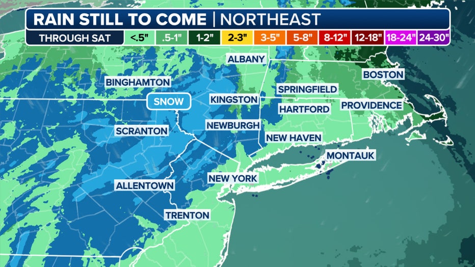
Forecast rain totals in the Northeast and New England should remain in the 1-2 inch range, although locally higher amounts of 2-3 inches or more are possible in some areas.
"Given the drought, the rain along the (Interstate) 95 corridor is significant," FOX Weather Meteorologist Stephen Morgan said. "Will we see more than an inch in New York City? I think there’s a pretty healthy shot over the next few days. Does it fall in one day? Maybe not."

This graphic shows forecast rain totals in the Northeast. (FOX Weather)
NYC weather radar
Click HERE for more.


