

Snowstorm hits NYC area: How many inches to expect during AM commute

NEW YORK CITY - Another winter storm arrived and was expected to bring more snow to the New York City area, which could make for a slick and slippery Wednesday morning commute.
SNOW STORM THIS WEEK: TIMELINE | PROJECTED TOTALS l WHAT'S NEXT
Winter weather alerts were issued for most of the NYC Tri-State, with Long Island, the Jersey Shore and Connecticut under a Winter Weather Advisory.
Here's a look at the weather forecast timeline, projected snow totals and what we know so far about the other winter weather threats this week.
Timeline: Snow tonight NYC
It’s going to be an extremely busy week weatherwise for the New York City area.
- 7 a.m. Wednesday: Winter Weather Advisory is lifted for Long Island, Connecticut and the Jersey Shore.
- 8 a.m. Wednesday: Residual snow will cover the city before the storm moves into the Atlantic.
- Wednesday morning and afternoon: Expect a cloudy, cold day.

Winter storm alerts have been issued throughout the Ohio Valley and mid-Atlantic through Thursday. (FOX Weather)
- 7 p.m.-9 p.m. Wednesday: Round two of snow moves in from the west. The area will see a mix of rain, snow and sleet, with rain more likely for the southern part of the region. Not much accumulation is expected.
- 2 a.m. Thursday: The wintry mix should transition to rain as the storm moves out of the area.
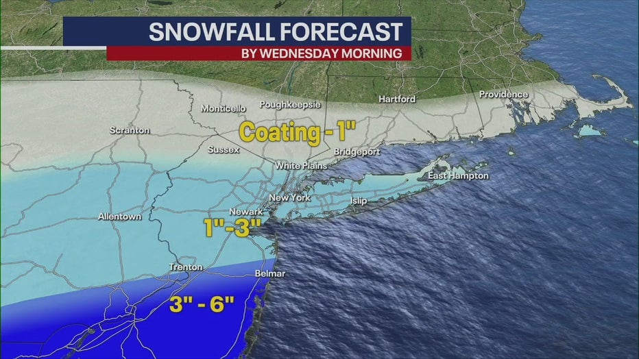
How much snow are we supposed to get?
Here's how much snow the area can expect by Wednesday morning – which doesn't factor in the Wednesday evening storm:
- NYC/NJ metro and Long Island: 1 to 2 inches likely, with local amounts of 3 inches possible. Snowfall rates of up to 1/2" / hr possible between 10 p.m. and 3 a.m.

(The National Weather Service)
- Coastal Connecticut, southern portions of the Lower Hudson Valley, and interior portions of northeastern NJ: Around an inch likely, with local amounts of 2" possible.
- Northern portions of the Lower Hudson Valley and southern Connecticut: Less than an inch likely across northern portions of the Lower Hudson Valley and southern Connecticut.
Meanwhile, South Jersey could see as much as 6 inches in some areas, with snowfall rates up to 1" per hour.
(The National Weather Service)
It's possible snow could mix with sleet and rain, which would reduce total snow amounts, the NWS said.
What they're saying:
"Not a ton of snow, but it is enough to make for some slick spots out there," FOX 5 NY's Mike Woods said. "Also, keep in mind, it's been very cold. So, that snow going to stick. So, icy conditions on the roadways tonight into tomorrow morning. That's what we're going to deal with."
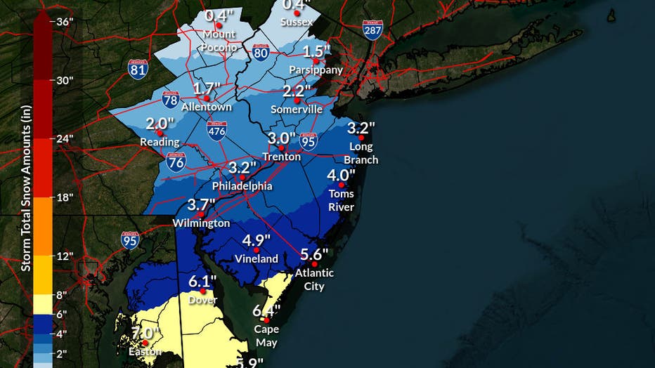
FOX 5 NY's Mike Woods' snowfall forecast.
Winter storm #2
What's next:
A midweek winter storm is also being monitored, and in fact, as the overnight storm begins to wind down, this one will be gaining strength.
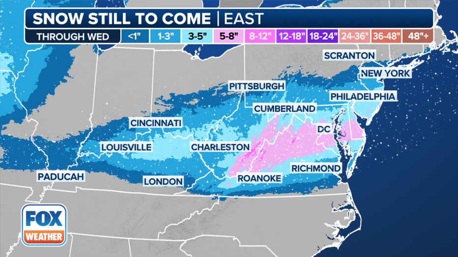
This graphic shows the forecast snow totals in the mid-Atlantic and Ohio Valley. (FOX Weather)
But as the system pushes off to the Northeast by Thursday, there's still some uncertainty regarding temperatures along the Interstate 95 corridor. Trends have been warmer, meaning New York City could once again miss out on a significant winter storm.
- Wednesday night: A second storm, which is forecast to dump snow onto the middle of the country, will move its way east by Wednesday night. According to the NWS, this could result in a mix of snow and sleet that transforms into rain, snow and sleet by early Thursday morning. Temperatures will be in the high-30s. The chance of precipitation is 100%. The wintry mix could impact the Wednesday evening commute.
- Thursday morning: Rain likely before 1 p.m. Mostly cloudy skies, with a high near 44. The chance of precipitation is 60%.
What we don't know:
As for storms expected later in the week, it's too early to tell if the Tri-State will see any accumulation at all. Forecasted high temperatures lingering above freezing make these chances slim.
"Snowfall totals will depend on how quick milder air arrives above the surface resulting in a change to a wintry mix," the NWS said.
The amount of icing will also depend on how quickly the temperatures rise above freezing.
Winter storm #3
This weekend: The last storm, for now, is expected to take shape late this week and continue into the weekend, bringing yet another round of winter weather to cities from the Plains to New England, according to FOX Weather. Woods forecasts a late Saturday wintry mix, as temperatures are likely to reach the 40s, but it's still too early to tell.

Potential snow totals this week. (FOX Weather)
The FOX Forecast Center said this relentless winter weather pattern could continue into next week, but it’s still too soon to know that for certain.
FOX Weather LIVE updates
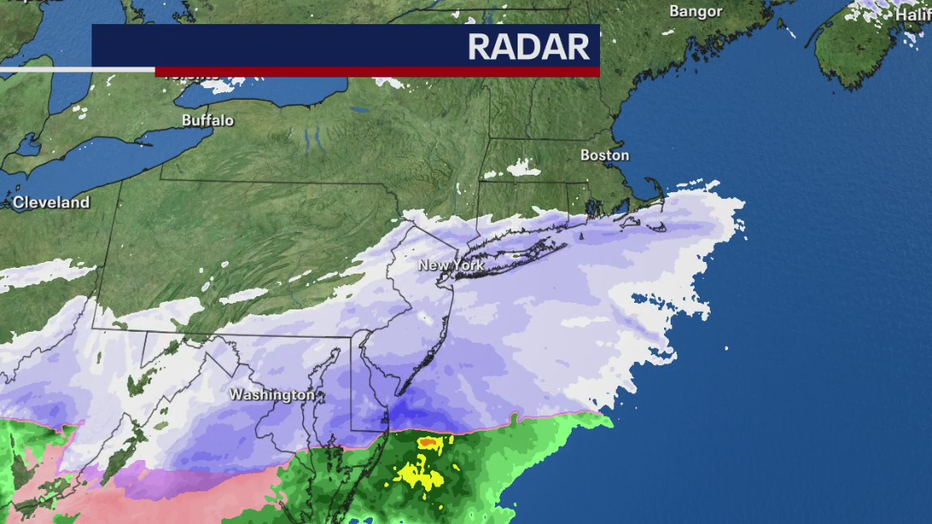
NYC weather radar
Click HERE for more information.