

Beryl update: Parts of NY face tornado threat. But will NYC see any remnants?

NEW YORK CITY - The remnants of what was once Hurricane Beryl are set to mostly miss NYC and head to northwest and upstate parts of NY, which could face a tornado threat. So, what's next for the Tri-State area? Here's what you need to know.
Today's weather NYC
- WHAT WE KNOW: Heat and humidity continues. Heat advisories, excessive heat warnings and air quality alerts remain in place for parts of the Tri-State area. Showers and thunder are possible into the evening, as well as an isolated severe thunderstorm and localized flash flooding.
- WHEN WILL IT RAIN: A slight chance of showers and thunderstorms is possible between 11 a.m. and 5 p.m., as well as between 11 p.m. and 5 a.m. – then a chance of showers after 5 a.m. Thursday.
- WHAT'S NEXT: The rain threat continues on Thursday and even into the weekend, with Friday seeing the best chance for showers.
NYC weather this week
Thursday
- A slight chance of showers before 8 a.m., then a slight chance of showers and thunderstorms between 8 a.m. and 2 p.m., then a slight chance of showers after 2 p.m. Partly sunny, with a high near 85. The chance of precipitation is 20%.
Featured

Beryl storm path: Will remnants bring a rainy week to NYC?
Beryl is reaching the final stages of its extended journey, as the storm's remnants shift into the Midwest. Will NYC be next in line? Here's what you need to know.
Friday
- Showers are likely, with thunderstorms also possible after 11 a.m. Partly sunny, with a high near 80. South wind 6 to 11 mph. The chance of precipitation is 60%.
Saturday
- A chance of showers, with thunderstorms also possible after 2 p.m. Partly sunny, with a high near 82. The chance of precipitation is 40%.
Sunday
- Sunny, with a high near 86.
Beryl path map
The combination of the remnants of Hurricane Beryl and a passing frontal boundary will result in a dual severe weather risk for the Northeast, bringing a rare tornado threat along with the chance of significant flooding through at least Thursday morning.
Across parts of central New York, the tornado threat is its highest in nearly 20 years.n.
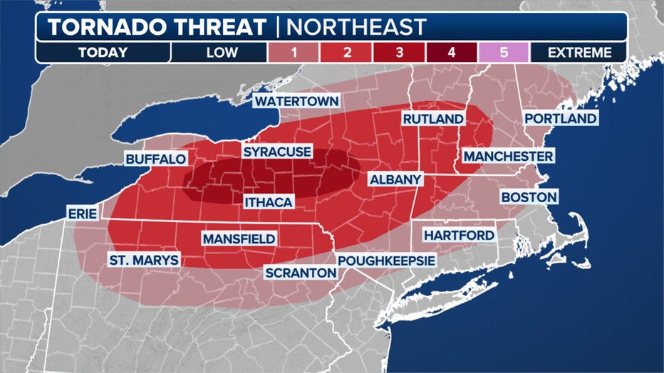
The greatest tornado threat will likely be within an east-to-west corridor from just southeast of Buffalo to just west of Albany. (FOX Weather)
"That should say something that should grab your attention," FOX Weather Meteorologist Craig Herrera said. "Watch for those supercells to develop this afternoon. You want to make sure that you’ve got a safe spot to go to."
NOAA's Storm Prediction Center has placed a swath of Upstate New York at a level 3 out of 5 severe weather risk.
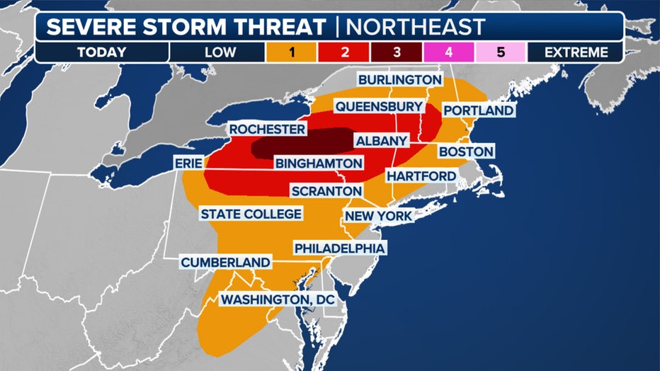
A look at the severe weather threat in the Northeast on Wednesday. (FOX Weather)
"The greatest tornado threat will likely be within an east-to-west corridor from just southeast of Buffalo to just west of Albany," SPC forecasters wrote Wednesday morning.
The worst weather is expected from mid-afternoon into the evening. Thunderstorms across the Northeast will also carry a threat of damaging wind gusts of 60 mph or greater.
FOX Weather's Andrew Wulfeck and Scott Sistek helped contribute to this report.