

Hurricane Milton path tracker: Latest models, updates and more l LIVE coverage
FLORIDA - Hurricane Milton made landfall late Wednesday evening south of Tampa near Sarasota, Florida, packing damaging winds, knocking power out to more than 2 million customers and triggering a significant tornado outbreak in the Sunshine State.
The St. Lucie County Sheriff's Office, located along the state's east coast, reported "multiple fatalities" associated with several tornadoes that rolled through.
HURRICANE MILTON LATEST UPDATE: LOCATION l PATH l IMPACTS
***MILTON TRACKER LIVE: Watch the video player above for coverage on the hurricane.
Gusts reached 94 mph in St. Petersburg, 87 mph in Palm Harbor and 77 mph in Davenport before the hurricane made landfall. A gust of 92 mph was also recorded in West Palm Beach, likely due to proximity to a tornado.

Hurricane Milton makes landfall in Florida
Hurricane Milton has crashed into Florida as a Category 3 storm, pounding the coast with ferocious winds of over 100 mph (160 kph) and producing a series of tornadoes around the state. Tampa avoided a direct hit.
The National Hurricane Center said Siesta Key had sustained winds of 73 mph and a gust to 102 mph at the pier, and not far away, a 102 mph wind gust was reported in Sarasota.
Featured

Hurricane Milton tracker: Live cameras from Florida
National Hurricane Center forecasters warned that Milton is "expected to be a dangerous major hurricane" when it reaches the Florida coast.
President Joe Biden spoke Wednesday evening about Milton, urging residents to listen to local officials and follow all safety instructions.
Biden also said that he has deployed federal resources to Florida to aid with any hurricane relief before and after the storm.
"We've got your back," he said.
"Milton has the potential to be one of the most destructive hurricanes on record for west-central Florida," the National Hurricane Center said Wednesday morning.
Here's everything you need to know about Hurricane Milton, including its location, projected path and impacts on Florida.
Milton location: Where is the hurricane now?
The storm system continues to race through Central Florida and is expected to emerge out over the Atlantic on Thursday.
During the period between landfall and Milton reemerging out over the Atlantic Ocean, central and northern Florida will experience the worst of what the storm has left to offer.
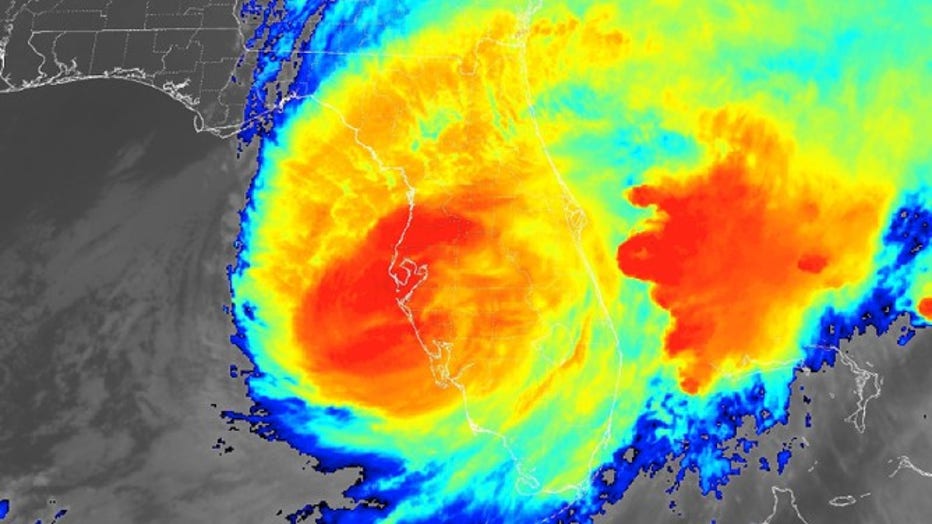
Milton Landfall (Credit: FOX Weather)
A Flash Flood Emergency was issued around the Tampa metro after more than 10" of rain was reported in less than 3 hours.
Projected path of Hurricane Milton 2024
The storm system continues to race through Central Florida and is expected to emerge out over the Atlantic on Thursday.
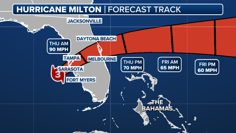
The forecast cone for Hurricane Milton. (FOX Weather)
Milton spaghetti models
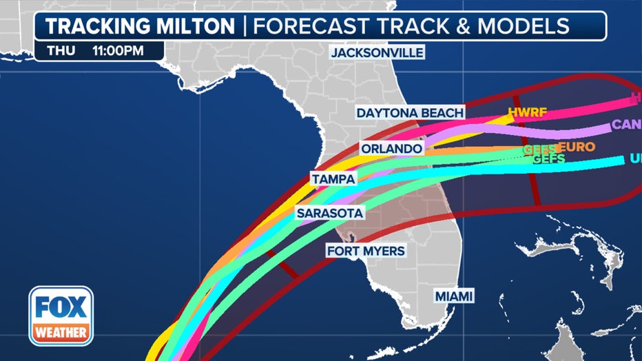
Spaghetti forecast models for Hurricane Milton. (FOX Weather)
Florida hurricane: Impacts
Storm surge forecasts along the central western coast are predicting 10-15 feet of water topped with devastating waves driven by hurricane-force winds. Those levels — significantly higher than the damage wrought just last month by Hurricane Helene – would surpass anything seen in over a century in the Tampa Bay area.
The NHC has lowered the forecast storm surge levels in Tampa Bay, but with the current storm surge forecast of 8-12 feet, the destruction could be catastrophic if that comes to fruition. Charlotte Harbor is also forecast to see a storm surge of up to 12 feet.
On the state's east coast, a storm surge of up to 5 feet is possible from Sebastian Inlet northward to the Florida-Georgia state line.
But even after landfall, damaging winds are expected to track across the central Florida Peninsula.
Aside from the life-threatening storm surge, Milton is forecast to bring wind speeds well over 100 mph around the eyewall where the hurricane makes landfall. That includes the Tampa area, which has potential wind gusts over 95 mph or more at landfall.

Power outage forecast during Hurricane Milton. (FOX Weather)
Milton is forecast to maintain hurricane strength even through its trek toward the state's Atlantic coast, with Hurricane Warnings covering 11 million, including the Orlando area and along the east coast from the St. Lucie/Martin County Line northward to Ponte Vedra Beach.
Storm surge will also be felt along the Atlantic coast of Florida from the Space Coast to the First Coast. This includes cities such as Daytona Beach, St. Augustine and Jacksonville Beach.
Rainfall totals will reach 8–12 inches along Milton's path, with isolated totals reaching 18 inches. And Milton will present a threat of several tornadoes even ahead of landfall.
Tornado in Florida today
Stunning videos from Florida Department of Transportation cameras along Interstate 75 in Alligator Alley between Broward and Palm Beach counties captured the destructive force of Milton's extreme weather in the state. FOX Weather Correspondent Brandy Campbell happened upon tornado damage in Fort Myers.
At least one person was seen being taken away via ambulance, as trees and debris littered roadways.
Featured

Tornado in Florida today captured as Hurricane Milton impacts state: VIDEO
A live camera from the Florida Department of Transportation spotted a confirmed tornado on the ground in South Florida as Hurricane Milton barreled toward the state.
Tampa evacuation zones
As Hurricane Milton barrels toward Florida, many Tampa Bay Area residents are preparing to evacuate.
Click HERE for more from our sister station, FOX 13 Tampa Bay.
Hurricane categories
What is a Category 1 hurricane?
A hurricane with maximum sustained winds of 74-95 mph is considered to be a Category 1 cyclone on the Saffir-Simpson Hurricane Wind Scale.
A Category 1 storm is the weakest of all hurricanes but is stronger than a tropical storm.
What is a Category 2 hurricane?
A hurricane with maximum sustained winds of 96-110 mph is considered to be a Category 2 cyclone on the Saffir-Simpson Hurricane Wind Scale.
A Category 2 storm is stronger than a Category 1 and is just one status below what is considered to be a major hurricane.
What is a Category 3 hurricane?
A hurricane with maximum sustained winds of 111-129 mph is considered to be a Category 3 cyclone on the Saffir-Simpson Hurricane Wind Scale.
Once a hurricane strengthens into Category 3 storm it is considered to be a major hurricane.
What is a Category 4 hurricane?
A hurricane with maximum sustained winds of 130-156 mph is considered to be a Category 4 cyclone on the Saffir-Simpson Hurricane Wind Scale.
A Category 4 cyclone is considered to be a major hurricane and is only one class below a Category 5.
What is a Category 5 hurricane?
A hurricane with maximum sustained winds of at least 157 mph is considered to be a Category 5 cyclone on the Saffir-Simpson Hurricane Wind Scale.
A Category 5 is the strongest a hurricane can get on the scale, as there is not a Category 6 rating.
When does hurricane season end?
The Atlantic hurricane season runs from June to November. August, September and October are considered to be the peak months, with more than 85% of tropical systems forming during the three-month period.
FOX Weather helped contribute to this report.