

Storm bringing more rain, flooding, high winds
Winter storm brings even more rain to region
All across our region, exhausted residents can't seem to catch a break as yet another storm is set to bring heavy rainfall to the region Friday night into Saturday morning.
NEW YORK - Parts of our area could see as much as two inches of rain on top of what we already got earlier this week as yet another storm makes its way through the region.
The National Weather Service says that widespread moderate river flooding, minor urban flooding and moderate to major coastal flooding can be expected all across the tri-state area, with the worst of the rainfall to happen between 10 p.m. Friday night and 8 a.m. Saturday morning.
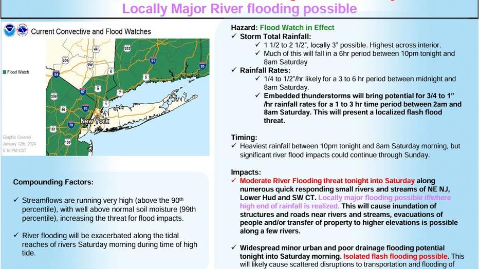
Credit: National Weather Service
While rainfall totals won't match Tuesday's storm, flood watches and warnings are again in effect for parts of northern New Jersey, the Hudson Valley and southern Connecticut.

Credit: National Weather Service
The storm is also expected to bring more strong winds across the area, with gusts of up to 45 to 55 miles per hour in some areas. The strongest winds are expected across eastern Long Island and southeastern Connecticut, where gusts of 60 mph are possible.
Several communities in New Jersey have been inundated by rainfall from the last week of storms.
Those living near the Passaic River have been hit particularly hard, with entire neighborhoods underwater.
In Paterson, city officials blocked off nearly two dozen streets due to standing water, while utility crews went door to door notifying residents that gas would be temporarily turned off for safety.
Earlier this week, Tuesday's storm dropped 2 to 4 inches of rain across the metro area, knocking out power to thousands of people.