

More snow Friday? Weather forecast shows new winter storm could hit NYC

NEW YORK - Fresh off the heels of measurable snow finally hitting NYC, the Tri-State area is likely to see another round of powdery and cold winter weather.
JUMP TO: LIVE RADAR | TRACK SCHOOL CLOSINGS
The potential for more snowfall accumulation is likely early Friday morning into Friday night, according to the National Weather Service, as another low-pressure system from the south travels up the coast.

The FOX Forecast Center will monitor the storm's evolution to see whether the system taps into more moisture to squeeze out even more snow for New York City. It won’t be a blockbuster snowstorm, but it will still be disruptive to travel, with snow totals ranging.

Another winter storm is set to make a cross-country journey through the end of the week. (FOX Weather)
Accumulating snow could cause issues on the roads and at airports throughout the day until the storm system exits the East Coast on Friday night.
First, however, NY, NJ and CT need to brace for frigid cold.
Will it snow on Friday? Timeline of events
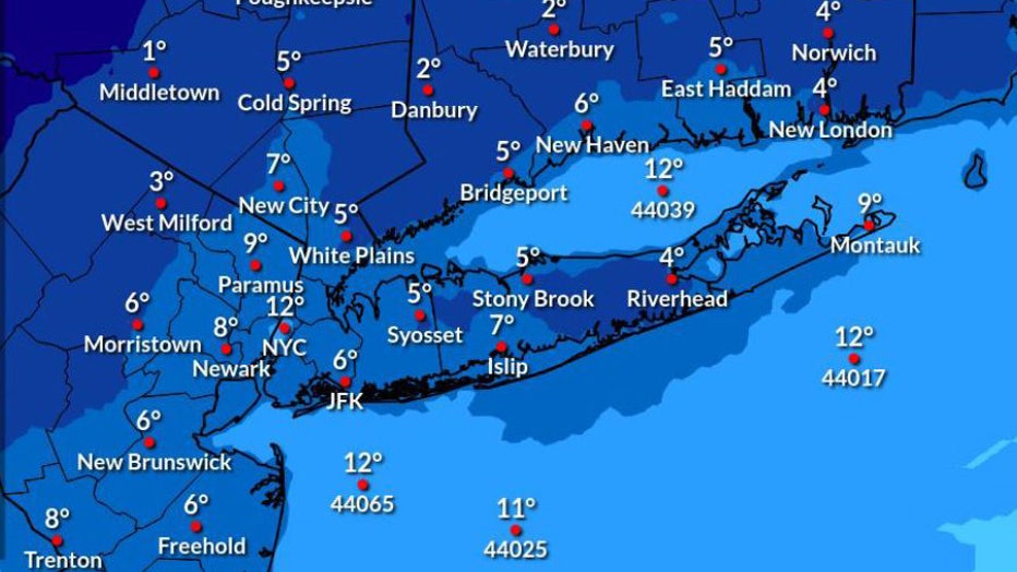
- Wednesday: Despite clear skies, temperatures are freezing, with a high near 26.
Wednesday night's wind chill. (National Weather Service)
- Thursday: Cold temperatures remain, with a high near 32. Clouds will fill skies as temperatures linger around 31 after nightfall.
- Friday at 1 a.m.: Snow could start to develop around this time.
- Friday: Light snow is expected to fall throughout the day and into the night. Snowfall amounts and rates largely depend on the "track and intensity of the low-pressure system," the NWS said.
How many inches of snow on Friday?
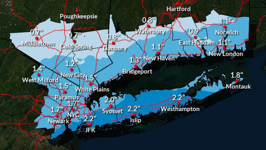
There is a 10 to 30% chance of snow accumulation exceeding 3 inches in New York City.
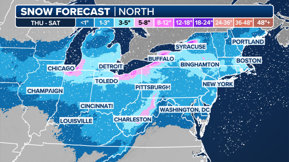
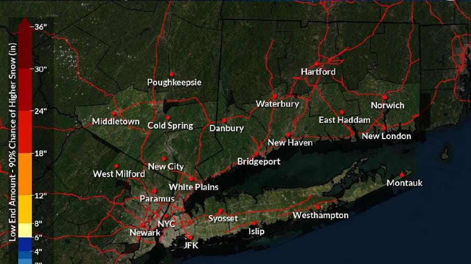
Forecast snow totals in the Northeast through Saturday, Jan. 20, 2024. (FOX Weather)
"You’ve got snow in the forecast, up and down the I-95 corridor," FOX Weather Meteorologist Craig Herrera said. "It’s a similar story to what we saw last time. We could see maybe 1 to 3 inches of snow, maybe a little bit more."
At the moment, the NWS projects about 1.7 inches of snowfall in New York City, with higher projections on Long Island and lower projections inland.
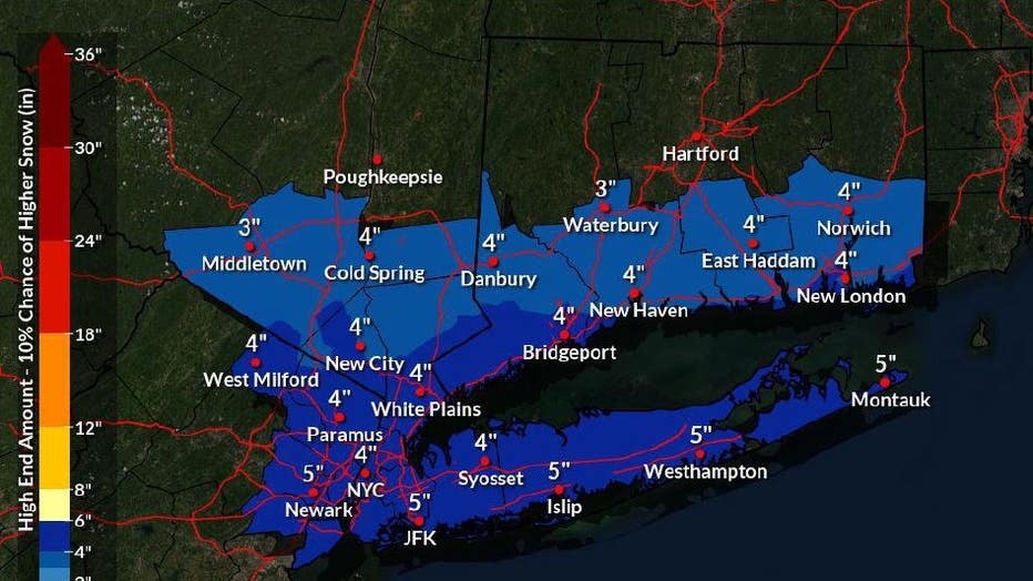
On the high end, NYC could see as much as 4 inches of additional snowfall, but inversely, low-end amounts show no additional snowfall at all.
"It’s a little bit of a dusting," FOX Weather Meteorologist Britta Merwin said. "The difference this go-around is that we’ve had a lot of cold air in place ahead. And that could make for more fluffy snow."
What's next after the snow?
- Saturday: If the area sees snow accumulation, it will certainly stick. NYC is expecting a blustery high of 24 and lows in the teens as the coldest airmass of the season arrives.
Saturday night's wind chill. (National Weather Service)
Tuesday's snow totals
The record snowless streak has finally ended after more than 700 days in New York City. Tuesday was the first time the city has picked up an inch of snow or more in a calendar day in nearly two years.
The highest snow total so far has been reported at Newark Liberty International Airport (EWR) in New Jersey. The airport has received 2.1 inches of snow.
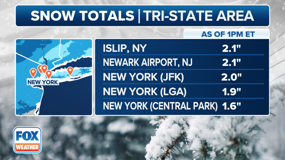
John F. Kennedy International Airport (JFK) picked up 2 inches, and LaGuardia Airport (LGA) received 1.9 inches of snow.
Behind that, New York City's Central Park reported 1.6 inches of snow.
Islip, Long Island, also received 2.1 inches of snow. And Bridgeport, Connecticut, also picked up 2 inches.
Steven Yablonski, with FOX Weather, helped contribute to this report.