

Snow arrives in Upstate New York: Here's when NYC will feel the chill

NEW YORK - A dusting of snow fell in Upstate New York Monday morning, according to FOX Weather.
FOX Weather said snowflakes were spotted in Saranac Lake outside the Hotel Saranac in the Adirondack village and near Lake Placid.
How has the weather been so far this month?
In the tri-state area, October has been exceptionally warm.
Our area has seen temperatures in the 60s to nearly 70 degrees.
FOX Weather said the cold air will invade the Northeast region, where snow showers are even possible in higher elevations.
"Much cooler temperatures push back into the tri-state tonight and they’ll stick around for awhile," FOX 5 NY's Mike Woods said in a post on X.
When will the cold air enter our area?
Most areas are expected to remain dry, but locations downwind of the Great Lakes face the chance for light rain showers, which could mix with snow in the higher elevations of the Northeast.
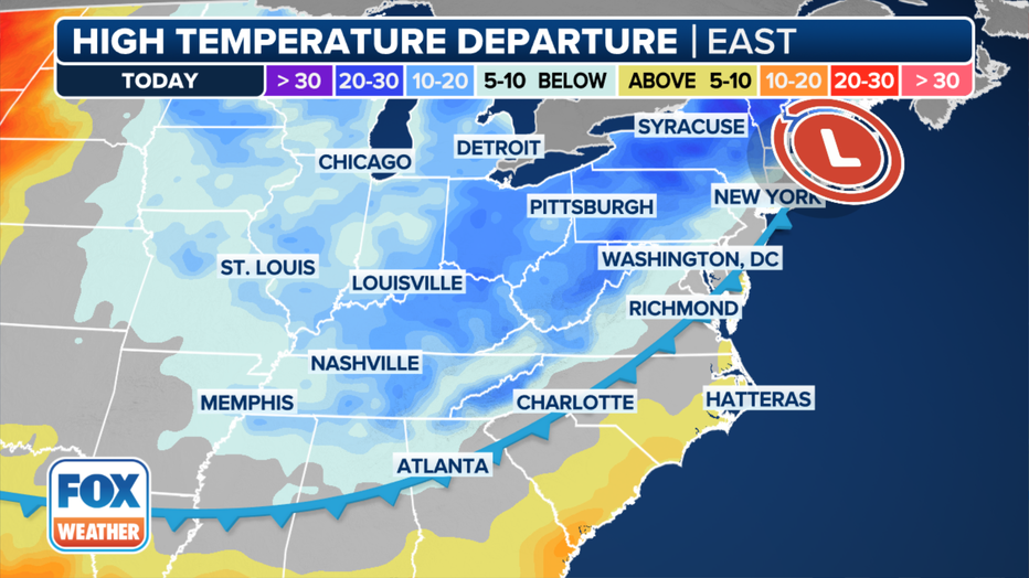
Forecast temperature departures from average across the eastern U.S. (FOX Weather)
The large-scale weather pattern will allow for gusty winds off the warm lakes, creating lake-effect rain and snow showers.
Computer forecast models from FOX Weather show that New York will be in store for the most precipitation, but again, those at lower elevations will experience all rain, as the cloud cover and warm water temperatures will help keep air temperatures above the freezing mark.
The cold air is expected to make its way to the Eastern Seaboard and the Interstate 95 corridor, where cities such as Boston, New York and Washington will all struggle to make it out of the 50s on Wednesday and Thursday.
Average first freeze date
The air mass generally falls in line with expectations for when to anticipate the first significant cooldown of the season.
Large parts of the Midwest, Great Lakes and New England typically experience their inaugural freeze during the first half of October, with the majority of the country seeing its first freeze from late October into early November.
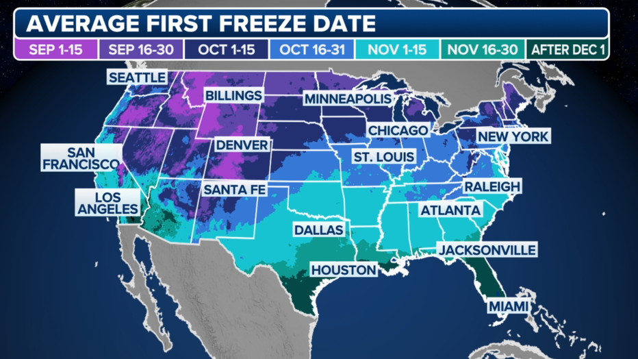
Average first freeze. (FOX Weather)
The first frost and freeze of the year signify the end of the growing season, as cooler temperatures can damage or kill tender plants.
Local National Weather Service offices have an arsenal of weather alerts that meteorologists can issue ahead of the chilly weather.
When temperatures are expected to remain generally above freezing but cold enough to produce a thin layer of ice, a Frost Advisory is issued.
Ahead of an event where temperatures are expected to drop to 32 degrees or below during the next 24-48 hours, meteorologists will issue a Freeze Watch, which will turn into a Freeze Warning as the event approaches.
These alerts are mainly used for agricultural purposes and advise people on the appropriate safeguards to protect vulnerable plants and crops.
Unlike cold air masses later in the season, the coming cooldown doesn’t appear to have staying power.
Computer forecast models show a round of above-average temperatures gaining hold in the Upper Midwest by Thursday and reaching the East Coast by the end of the upcoming weekend.
An area of high pressure centered over the eastern U.S. and western Atlantic will help ensure that easterly to southerly breezes send temperatures 5-15 degrees above average, which could last for a substantial portion of the remaining days of the month.
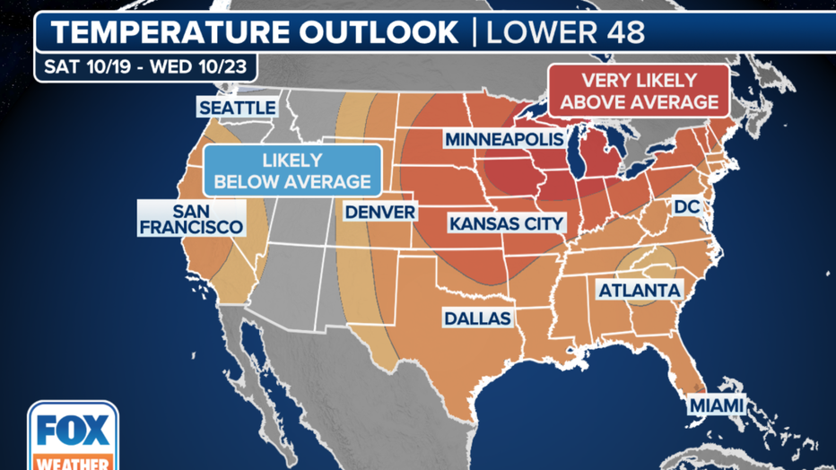
The 6- to 10-day temperature outlook from NOAA's Climate Prediction Center. (FOX Weather)
FOX Weather contributed to this report.