

Hurricane Francine makes landfall: Could storm remnants impact NYC?
Hurricane Francine makes landfall in Louisiana
Hurricane Francine has made landfall in Louisiana as a Category 2 storm, bringing powerful winds, deadly storm surge and potential flooding on the northern U.S. Gulf Coast.
NEW YORK CITY - Hurricane Francine barreled into southern Louisiana on Wednesday evening as a category 2 storm, making landfall with destructive 100 mph winds and dangerous storm surge along the Bayou state's coastline. But will the storm's remnants eventually impact NYC?
The eye of Francine moved onshore at 5 p.m. CT in Terrebonne Parish continuing to bring hurricane-force winds inland into the southern region of the state near Baton Rouge.
HURRICANE FRANCINE UPDATES: LOCATION l PATH l NYC IMPACTS
***Click each headline to jump to the designated topic.
As stormy conditions arrived Wednesday afternoon, Louisiana officials urged residents to stay put until first responders could safely reach them if needed. Conditions created by Francine also brought the threat of tornadoes and severe thunderstorms, which will continue into Wednesday night and early Thursday.
Here's everything you need to know about Hurricane Francine, including its location, projected path and potential NYC impacts.
Hurricane Francine live tracker
Hurricane-force winds from Francine’s northern eyewall are moving onshore and spreading inland into the southern region of Louisiana. The National Hurricane Center (NHC) said life-threatening storm surge is spreading across coastal Louisiana, and conditions will continue to worsen throughout the afternoon and into the evening.
Multiple parishes in Louisiana have issued mandatory evacuation orders as the Category 2 hurricane is set to make landfall with widespread power outages, significant flooding and some property damage.
Here's the latest information on Hurricane Francine. (FOX Weather)
As of the latest advisory from the National Hurricane Center (NHC), Francine is located about 30 miles southwest of Morgan City, Louisiana, or about 85 miles southwest of New Orleans, and moving northeast at about 17 mph. Maximum sustained winds are near 100 mph with higher gusts.
Path of Francine
The NHC said Francine is expected to take a gradual turn toward the north, bringing the center of Francine across southeastern Louisiana and southwestern and central Mississippi on Thursday.
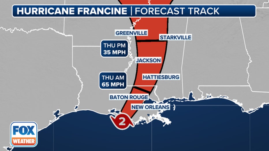
Forecast cone for Hurricane Francine. (FOX Weather)
Francine became a hurricane on Sept. 10, marking the peak of the 2024 hurricane season when a named storm is most likely to be roaming the Atlantic Basin. As Francine heads north and eventually dissipates, the NHC is also tracking several other systems in the Atlantic.
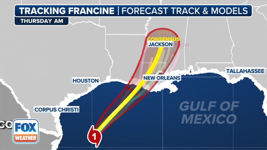
Here are the spaghetti models for Hurricane Francine. (FOX Weather)
Francine is expected to bring total rainfall of 4–8 inches, with local amounts up to 12 inches across eastern Louisiana, Mississippi, far southern Alabama and the western Florida Panhandle through Friday morning.
From evacuations to proactively clearing storm drains, many places have already taken precautions to safeguard life and property.
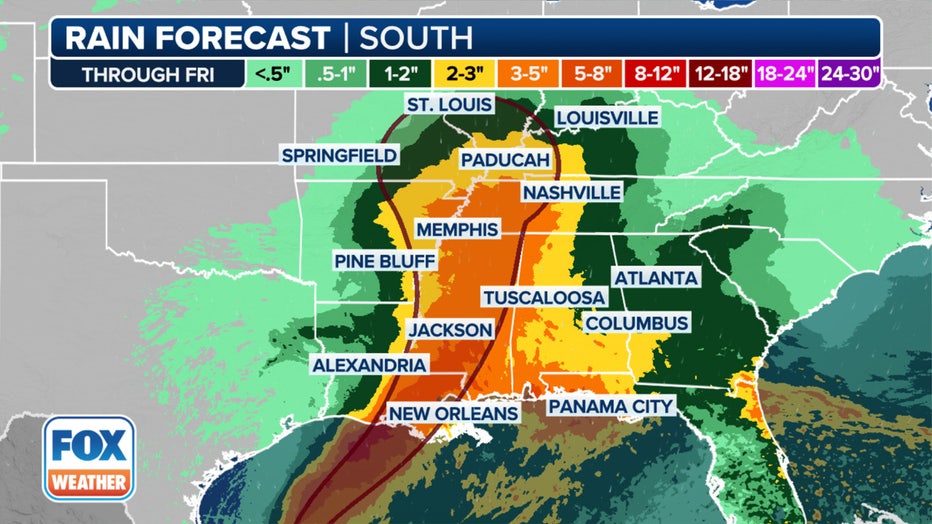
A look at the rain forecast for Francine. (FOX Weather)
The rain could lead to considerable flash and urban flooding.
Where are watches and warnings in effect?
The NHC has issued a Hurricane Warning for the Louisiana coast from Cameron to Grand Isle, which includes Baton Rouge. Tropical Storm and Storm Surge Warnings now extend from Louisiana to Alabama.
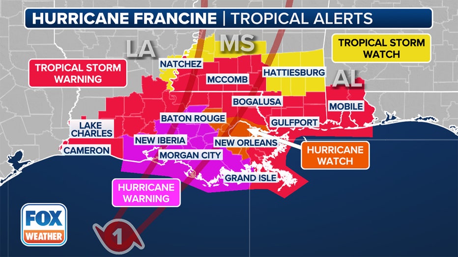
Here are current watches and warnings in effect because of Hurricane Francine. (FOX Weather)
Power outages were creeping up on Wednesday after landfall with more than 20,500 outages across Louisiana, according to Poweroutage.us.

Here is the power outage forecast for Hurricane Francine. (FOX Weather)
Tropical storm conditions are expected in the warning area along the coasts of Louisiana, Mississippi and Alabama through Wednesday night.
Hurricane Francine evacuations
Just south of Lake Charles, Cameron Parish issued mandatory evacuations on Tuesday, leaving the area eerily quiet. In Morgan City, located closer to the coast, voluntary evacuations have been put in place. Businesses are boarding up, and residents are scrambling to stock up on gas and food before the storm hits.
All New Orleans Public Schools dismissed students early on Tuesday and will remain closed on Wednesday and Thursday.
In Baton Rouge, Mayor-President Sharon Weston Broome said she has been in constant contact with the National Weather Service, along with local and state officials, as preparations are made for Francine's landfall.
"This storm is expected to bring threats of heavy rain, gusty to damaging winds and possibly a few tornadoes," she said. "I want to encourage everyone to make preparations now."
New York City's potential impacts
Will the remnants of Hurricane Francine impact NYC? If they do, it won't be this week, according to FOX 5 NY's Mike Woods.
"Are we going to get anything out of it?" Woods said. "Well, if we do, it would be next week."
Woods says it depends on another area of low pressure.
"In the Southeast Atlantic waters, there may be an area of low pressure that develops next week and starts to tap into some of the moisture that's left over from Francine, and therefore, it could be bringing us some showers by maybe later Tuesday into Wednesday of next week," Woods said.
FOX Weather's Chris Oberholtz, Emilee Speck and Steven Yablonski helped contribute to this report.