

Route 80 sinkhole in NJ: Highway closed at Exit 34 until further notice

NJ sinkhole disrupts traffic
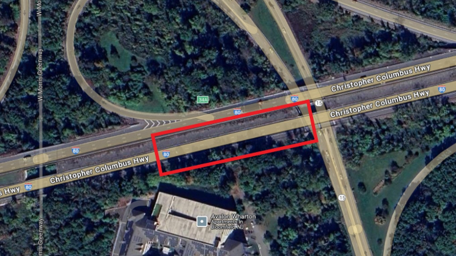
A massive 15-by-15-foot sinkhole has forced the indefinite closure of I-80 westbound at Exit 34 in Wharton, New Jersey. FOX 5's Meredith Gorman reports from the scene, where drivers are being rerouted and local businesses are already feeling the impact.
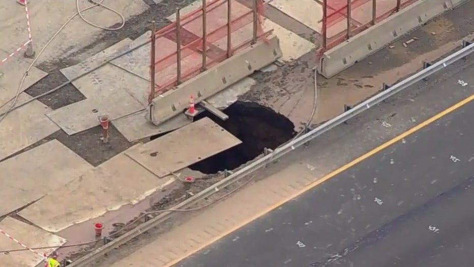
Both eastbound and westbound lanes of New Jersey's Route 80 near Exit 34 will be closed until further notice as crews work to repair the massive sinkholes forming thanks to abandoned mines.
The latest 15-foot by 15-foot sinkhole appeared Wednesday along the median in the westbound lane near Exit 34 in Wharton, just feet away from an 11-foot by 11-foot sinkhole discovered in the eastbound lane in February.
JUMP TO: TRAFFIC MAP | DETOURS | UPDATES | SINKHOLE TRACKER
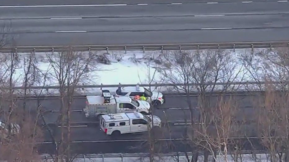
Before the highway can reopen, crews must repair the sinkholes, run tests and install a monitoring system. Gov. Phil Murphy had declared a state of emergency for Morris County after the February sinkhole appeared in hopes that federal funds could expedite the efforts.
Here's how you can track updates and view a live traffic map and find detours:
Live NJ traffic map and updates
Below you'll find a live traffic map from NJ511. Click here if you're having trouble viewing the map.
How to track updates
NJDOT has created a web page to keep the public informed about the progress of repairs.
Detours
What you can do:
State officials urge drivers not to rely on GPS for detours, as many services will reroute vehicles onto local roads. Instead, the following routes are recommended:
Courtesy: NJDOT
I-80 eastbound Exit 34 Detour:
Motorists on Route 15 southbound wishing to take the bridge over Rockaway River will be directed to:
- Motorists on I-80 eastbound are being directed to take Exit 34 to Route 15/Wharton/Dover/Sparta
- At the end of the ramp, stay right following signs for Route 15/Jefferson/Dover/Sparta/Picatinny Arsenal
- Stay in the right lane on North Main Street following signs for Route 15 North/Jefferson/Sparta
- Bear right toward Route 15 northbound/Picatinny Arsenal
- Stay left, following signs for Pondview Drive/U and Left Turns
- Using both lanes, make a U-turn at the Pondview Drive traffic signal and merge onto Route 15 southbound
- Stay left to take the exit to I-80 eastbound
I-80 westbound traffic is being detoured at Exit 34B. The following detour is in place:
I-80 westbound Exit 34B Detour:
Motorists on Route 15 southbound wishing to take the bridge over Rockaway River will be directed to:
- Motorists on I-80 westbound will be directed to take Exit 34B to Route 15 north/Jefferson/Sparta
- Keep left on Route 15 northbound
- Use the left two left lanes at Pondview Drive to make a U-turn onto Route 15 southbound
- Stay right to take the ramp to I-80 westbound
Route 10 eastbound Alternate Route:
- Motorists on I-80 eastbound are advised to take Exit 28/Route 46 eastbound to Route 10/Ledgewood/Lake Hopatcong, which is several miles before the closure
- Continue on Route 46 eastbound
- Stay right to take Route 10 eastbound
- Take the exit to I-287 northbound
- Stay right to take the ramp to I-80 eastbound
Route 46 eastbound Alternate Route:
- Motorists on I-80 eastbound are advised to take Exit 28/Route 46 eastbound to Route 10/Ledgewood/Lake Hopatcong, which is several miles before the closure
- Continue on Route 46 eastbound
- Stay in the two left lanes to turn left at the traffic signal to continue on Route 46 eastbound
- Turn left onto Route 15 northbound in Dover, back to I-80
- Stay right to take the ramp to I-80 eastbound
- Continue on Route 46 eastbound for about 12 miles and stay left for I-80 eastbound
The view from SkyFOX shows crews on site to evaluating the sinkhole that appeared in February.
Tracking the sinkholes
What we know:
Since winter, three sinkholes have appeared on Route 80:
- A 40-foot by 40-foot sinkhole in the right shoulder of I-80 eastbound near mile post 34, repaired in late December 2024.
- An 11-foot by 11-foot sinkhole in the center lane of I-80 eastbound at Exit 34, observed and stabilized in February 2025.
- A 15-foot by 15-foot sinkhole in the median of the I-80 eastbound work zone, which appeared in March 2025.
How did the sinkholes form?
The backstory:
The collapse of an abandoned mineshaft beneath Route 80 in Morris County, New Jersey, on December 26, underscores the significant risk posed by the state's nearly 600 abandoned mines. These mines, scattered across nine northern counties, can lead to sudden and dangerous sinkholes, NJ.com reports.
New Jersey has a rich history of mining, particularly for iron ore, copper, and other minerals, and the hilly terrain in the state's northwest became known for its mineral deposits.
Mining activities in the state began as early as the 18th century and continued into the 19th and early 20th centuries. Advances in technology and shifts in economic priorities led to the closure of many mines.
The New Jersey Department of Transportation is reviewing subsurface conditions to assess stability, but the extent of underground mine networks remains largely unknown.
What they're saying:
Some nearby businesses say the detours are beginning to hit their bottom line.
"My business hasn't taken a major hit, but some of the businesses in town have," said Jim Hill, owner of the Knotty Pine Pub in Wharton. "I'm down 10, 20%, which isn't devastating but it hurts a little bit."
Meanwhile, residents at the Avalon Apartment Complex, which is roughly 150 feet away from the sinkhole and the construction to repair it, say that they are worried over cracks in the building and in the parking garage they think are due to the sinkhole.
In a statement, AvalonBay told FOX 5 NY that the building is safe:
The Source: This article uses information from the NJDOT and NJ.com.