

Long Island storm forecast: South Shore sees coastal flooding threat, wind gusts upward of 60 mph
Long Island flooding
FOX 5 NY's Jodi Goldberg spoke with people who live near the water about adjusting to this evolving weather.
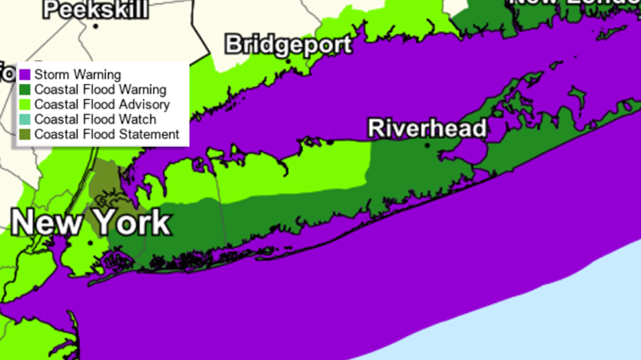
LONG ISLAND - As a powerful storm approaches the NYC area, the entirety of Long Island is under a high wind warning, and a coastal flood warning covers the South Shore and parts of the North Shore, according to the National Weather Service.
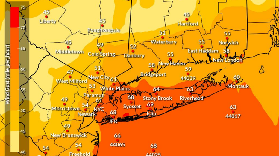
Widespread power outages are likely as peak winds could reach 30 to 40 miles per hour with gusts up to 70 miles per hour. The strongest winds are expected between 10 p.m. Tuesday and 5 a.m. Wednesday.
A State of Emergency has been issued in Nassau and Suffolk Counties to assist with recovery if needed - this as crews were out clearing storm basins to prevent flooding.
A staging area has been set up in Bethpage for trucks coming in from outside of Long Island. They’re able to fuel up before heading to areas they’re needed the most.
Click here for a full list of school closing and delays throughout our area
Widespread coastal flooding is expected from Queens to East Patchogue on the South Shore, with the most extreme conditions during Wednesday morning's high tide.
How much rain is expected on Long Island?
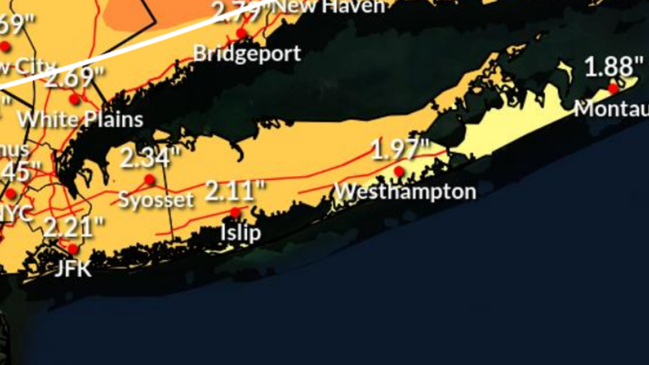
Most of Long Island will see 2-2.5 inches of rain.
When is it going to rain?
The heaviest rainfall is going to be between 7 p.m. Tuesday evening and 5 a.m. Wednesday morning, but significant flood impacts are likely to continue through Thursday morning.
Damaging winds across the Island could knock out power
The heavy rain combined with strong winds could lead to downed trees and power lines, resulting in widespread power outages.
PSEG Long Island wants its customers to know they’re prepared for heavy rain and wind late Tuesday night into Wednesday. They’ve got 500 employees ready to respond with outside utility personnel from as far south as Florida and west as Kentucky coming in to help. Larry Torres is the senior director of emergency preparedness and logistics.
"We have over 400 high-voltage resources from those areas and we’re bringing in additional vegetation crews and over 100 additional wire watchers and damage accessors as well," Torres said.
Strong winds will last through Wednesday as the system exits the region.

The power outage forecast for the East Coast. (FOX Weather)
The highest wind gusts will likely be seen in Islip, at 69 miles per hour. Most wind gusts on Long Island will be in the 60-mile range.
"The biggest concern is the heavy, heavy rains and the forecasted gusts approaching 70 mph and that’s what we’re preparing for," Torres said.
Featured


NYC storm watch: Torrential rain could cause major flooding, power outages in NY, NJ, CT: forecast
A powerful storm is bearing down on New York City, set to slam parts of New York, New Jersey and Connecticut with heavy rain, possible flooding, high winds and the potential for widespread power outages.
To see the full list of advisories, watches and warnings for the NYC area, click HERE.
Coastal flooding hazards and impact
Coastal flood warnings and advisories are in effect from 4 p.m. Tuesday to 1 p.m. Wednesday.
Moderate flooding is expected along the South Shore, and major flooding is also possible for coastal communities along the Great South Bay.
Some areas of the South Shore could see a surge of 4 to 5 feet between Tuesday evening and Wednesday morning high tides.
Large breaking waves of 15 to 20 feet along the oceanfront will also result in widespread dune erosion and damage to dune structures.