Hurricane Helene projected path: Tracker, spaghetti models and more l LIVE UPDATES
FLORIDA - Helene reached hurricane strength Wednesday morning as it continues to undergo rapid intensification along its journey into the Gulf of Mexico, where it is aiming for a destructive landfall along the Florida Gulf Coast on Thursday.
LATEST ON HURRICANE HELENE: LOCATION l PROJECTED PATH l IMPACTS
***Click each headline to jump to the designated topic.
Hurricane Warnings and Storm Surge Warnings spread across the west coast of Florida as Helene is forecast to become a major hurricane, bringing the potential for life-threatening storm surge, flooding rain and destructive hurricane-force winds.

A look at the exclusive FOX Model showing wind gust potential in the Gulf Coast on Thursday. (FOX Weather)
The National Hurricane Center says there is danger of life-threatening storm surge along the entire west coast of the Florida Peninsula and Big Bend, with the highest water levels – as much as 15 feet above dry land – expected in the Big Bend area as the storm comes ashore late Thursday. Tampa Bay could see 5-8 feet of storm surge inundation under current forecasts.
Here's everything you need to know about Hurricane Helene, including its location, projected path and impacts.
Where is Hurricane Helene?
Hurricane Helene is currently located near Mexico's Yucatan Peninsula.
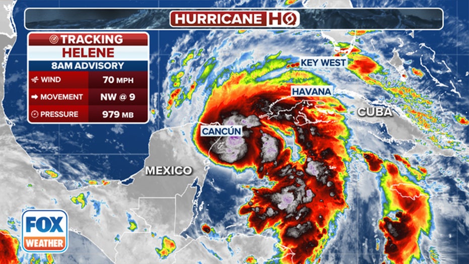
The latest information on Tropical Storm Helene. (FOX Weather)
Helene's maximum sustained winds have increased to at least 75 mph with higher gusts, according to the NHC's latest update.
Where is Hurricane Helene going to hit?
Helene has rapidly intensified as it approaches the southeastern Gulf of Mexico and is expected to become a major hurricane, defined as winds of at least 115 mph, as it moves toward the northeastern Gulf Coast on Thursday.
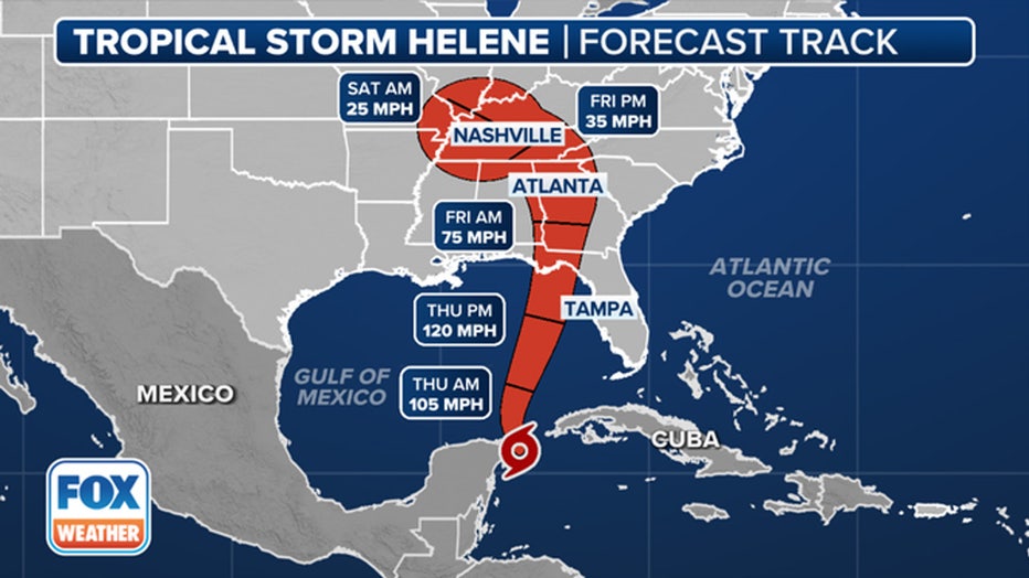
This graphic shows the forecast track for Hurricane Helene. (FOX Weather)
Hurricane Helene projected path: Spaghetti models

Here are the spaghetti models for Hurricane Helene. (FOX Weather)
The current 120-mph peak intensity forecast would rate the storm a Category 3 hurricane on the Saffir-Simpson Scale.
What watches and warnings are in effect?
A Hurricane Warning has been issued from Anclote River to Mexico Beach, Florida, where damaging hurricane-force winds are expected later Thursday. The NHC is urging those in the warning areas to complete any preparations by early Thursday morning.

Current tropical alerts in effect for Hurricane Helene. (FOX Weather)
Tropical Storm Warnings are in effect for all the Florida Keys, Dry Tortugas and the west coast of Florida from Flamingo to Anclote River, including Tampa Bay. West of Mexico Beach to the Walton/Bay County line, the east coast of Florida from Flamingo northward to the mouth of the St. Mary's River, and Lake Okeechobee.
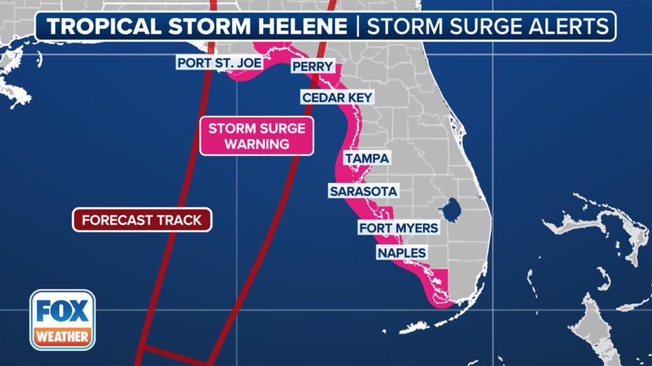
A look at the storm surge alerts issued in Florida. (FOX Weather)
Helene is expected to be a large hurricane in size – perhaps ranking among the 90% percentile among typical hurricanes of the area, according to the NHC.
Hurricane Helene impacts for Florida
With the large storm size and track, a life-threatening storm surge is possible. Water could reach 10-15 feet above dry level if the surge comes in at high tide between the Ochlockonee River and Chassahowitzka along Florida's Big Bend, according to the NHC.
A storm surge of varying heights is expected all along the entire west coast of Florida, with higher levels expected the closer you get to Helene's eventual landfall.
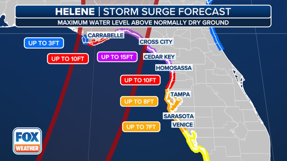
The storm surge forecast for the Gulf Coast of Florida. (FOX Weather)
Torrential rains from Helene will bring "considerable" flash and urban flooding across the Southeast, according to the NHC, with accumulations of 4 to 8 inches and isolated totals of about 12 inches. Significant river flooding is also a risk.
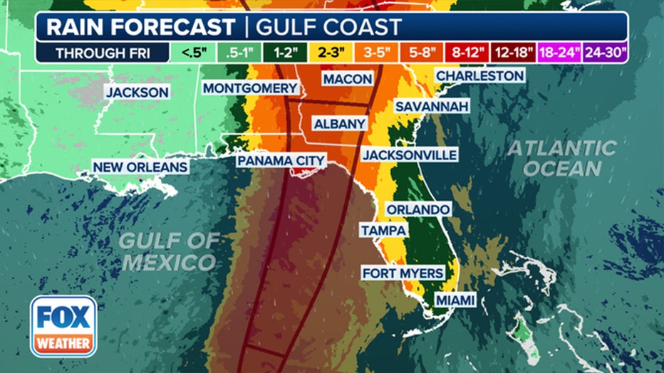
The rainfall forecast for the Southeast because of Hurricane Helene. (FOX Weather)
Steven Yablonski, Emilee Speck and Scott Sistek, from FOX Weather, helped contribute to this report.

